Chinese Journal OF Rice Science ›› 2022, Vol. 36 ›› Issue (3): 308-317.DOI: 10.16819/j.1001-7216.2022.210712
• Research Papers • Previous Articles Next Articles
CAO Zhongsheng1, LI Yanda1,*( ), HUANG Junbao1, YE Chun1, SUN Binfeng1, SHU Shifu1, ZHU Yan2, HE Yong3
Received:2021-07-29
Revised:2021-11-04
Online:2022-05-10
Published:2022-05-11
Contact:
LI Yanda
曹中盛1, 李艳大1,*(), 黄俊宝1, 叶春1, 孙滨峰1, 舒时富1, 朱艳2, 何勇3
通讯作者:
李艳大
基金资助:CAO Zhongsheng, LI Yanda, HUANG Junbao, YE Chun, SUN Binfeng, SHU Shifu, ZHU Yan, HE Yong. Monitoring Rice Leaf Area Index Based on Unmanned Aerial Vehicle (UAV) Digital Images[J]. Chinese Journal OF Rice Science, 2022, 36(3): 308-317.
曹中盛, 李艳大, 黄俊宝, 叶春, 孙滨峰, 舒时富, 朱艳, 何勇. 基于无人机数码影像的水稻叶面积指数监测[J]. 中国水稻科学, 2022, 36(3): 308-317.
Add to citation manager EndNote|Ris|BibTeX
URL: http://www.ricesci.cn/EN/10.16819/j.1001-7216.2022.210712
| 参数 Parameter | 数值 Value |
|---|---|
| 传感器 Sensor | 1/2.3 英寸CMOS |
| 有效像素 Effective pixels | 1 235 万 |
| 最大分辨率 Maximum resolution | 4000 × 3000 |
| 质量 Quality | 734 g |
| 续航时间 Battery terms | 21 min |
Table 1. Parameters of unmanned aerial vehicle (UAV) and digital camera.
| 参数 Parameter | 数值 Value |
|---|---|
| 传感器 Sensor | 1/2.3 英寸CMOS |
| 有效像素 Effective pixels | 1 235 万 |
| 最大分辨率 Maximum resolution | 4000 × 3000 |
| 质量 Quality | 734 g |
| 续航时间 Battery terms | 21 min |
| 序号 Number | 颜色指数 Color index | 计算公式 Equation | 参考文献 Reference |
|---|---|---|---|
| 1 | 红光标准化值NRI Normalized redness intensity | r/(r+g+b) | [ |
| 2 | 绿光标准化值NGI Normalized greenness intensity | g/(r+g+b) | [ |
| 3 | 蓝光标准化值NBI Normalized blueness intensity | b/(r+g+b) | [ |
| 4 | 归一化绿红差值指数NGRDI Normalized green minus red difference index | (g-r)/(g+r) | [ |
| 5 | 超绿植被指数ExG Excess green vegetation index | 2g-r-b | [ |
| 6 | 超红植被指数ExR Excess red vegetation index | 1.4r-b | [ |
| 7 | 超绿超红差分植被指数ExGR Excess green minus excess red vegetation index | ExG-ExR | [ |
| 8 | 可见光大气阻抗植被指数VARI Visible light atmospheric resistant vegetation index | (g-r)/(g+r-b) | [ |
| 9 | 绿叶植被指数GLI Green leaf vegetation index | (2g-b-r)/(2g+b+r) | [ |
Table 2. Equations of color indices.
| 序号 Number | 颜色指数 Color index | 计算公式 Equation | 参考文献 Reference |
|---|---|---|---|
| 1 | 红光标准化值NRI Normalized redness intensity | r/(r+g+b) | [ |
| 2 | 绿光标准化值NGI Normalized greenness intensity | g/(r+g+b) | [ |
| 3 | 蓝光标准化值NBI Normalized blueness intensity | b/(r+g+b) | [ |
| 4 | 归一化绿红差值指数NGRDI Normalized green minus red difference index | (g-r)/(g+r) | [ |
| 5 | 超绿植被指数ExG Excess green vegetation index | 2g-r-b | [ |
| 6 | 超红植被指数ExR Excess red vegetation index | 1.4r-b | [ |
| 7 | 超绿超红差分植被指数ExGR Excess green minus excess red vegetation index | ExG-ExR | [ |
| 8 | 可见光大气阻抗植被指数VARI Visible light atmospheric resistant vegetation index | (g-r)/(g+r-b) | [ |
| 9 | 绿叶植被指数GLI Green leaf vegetation index | (2g-b-r)/(2g+b+r) | [ |
| 序号 Number | 纹理特征 Texture feature | 简写 Abbreviation | 说明 Description |
|---|---|---|---|
| 1 | 均值 Mean | MEA | 反映纹理的平均值 |
| 2 | 方差 Variance | VAR | 反映纹理的变化情况 |
| 3 | 均一性 Homogeneity | HOM | 反映纹理的同质性 |
| 4 | 对比度 Contrast | CON | 反映纹理的清晰度 |
| 5 | 异质性 Dissimilarity | DIS | 反映纹理的相似性 |
| 6 | 熵 Entropy | ENT | 反映纹理的复杂程度 |
| 7 | 角二阶矩 Second moment | SEC | 反映纹理粗细度 |
| 8 | 相关性 Correlation | COR | 反映纹理的一致性 |
Table 3. Description of texture features.
| 序号 Number | 纹理特征 Texture feature | 简写 Abbreviation | 说明 Description |
|---|---|---|---|
| 1 | 均值 Mean | MEA | 反映纹理的平均值 |
| 2 | 方差 Variance | VAR | 反映纹理的变化情况 |
| 3 | 均一性 Homogeneity | HOM | 反映纹理的同质性 |
| 4 | 对比度 Contrast | CON | 反映纹理的清晰度 |
| 5 | 异质性 Dissimilarity | DIS | 反映纹理的相似性 |
| 6 | 熵 Entropy | ENT | 反映纹理的复杂程度 |
| 7 | 角二阶矩 Second moment | SEC | 反映纹理粗细度 |
| 8 | 相关性 Correlation | COR | 反映纹理的一致性 |
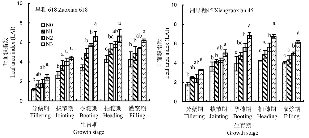
Fig. 1. Dynamic changes of rice leaf area index at different fertilizer-N application levels.
| 颜色指数和纹理特征 Color index and texture feature | 相关系数 Correlation coefficient | |||||||
|---|---|---|---|---|---|---|---|---|
| 分蘖期 Tillering | 拔节期 Jointing | 孕穗期 Booting | 抽穗期 Heading | 灌浆期 Filling | 分蘖期+拔节期 Tillering+Jointing | 孕穗期+抽穗期+灌浆期 Booting+Heading+Filling | 全生育期 All | |
| R | -0.476** | -0.642** | -0.429** | -0.277 | 0.009 | 0.050 | -0.372** | 0.098 |
| G | -0.327 | -0.478* | -0.263 | -0.160 | -0.043 | 0.074 | -0.340** | -0.021 |
| B | -0.327 | -0.472* | -0.083 | 0.116 | -0.104 | 0.248 | -0.035 | 0.159 |
| NGRDI | -0.072 | 0.221 | -0.108 | 0.002 | -0.066 | 0.145 | 0.117 | -0.292** |
| ExG | 0.182 | 0.392 | -0.057 | -0.247 | -0.006 | -0.316* | -0.338** | -0.396** |
| ExR | -0.736** | -0.712** | -0.559** | -0.402** | 0.109 | 0.004 | -0.380** | -0.301** |
| ExGR | -0.176 | 0.154 | -0.252 | -0.116 | 0.042 | -0.146 | -0.222 | 0.172 |
| VARI | 0.258 | 0.586** | -0.292 | -0.038 | 0.076 | 0.808** | 0.247* | 0.211** |
| GLI | 0.366* | 0.080 | 0.080 | 0.121 | 0.076 | -0.336* | 0.116 | -0.346** |
| MEA | -0.644** | -0.377 | -0.463* | -0.582** | 0.088 | 0.018 | -0.349** | 0.124 |
| VAR | 0.768** | 0.759** | 0.628** | 0.483** | -0.096 | 0.910** | 0.400** | 0.513** |
| HOM | -0.735** | -0.448* | -0.478** | -0.481** | 0.047 | 0.786** | -0.348** | -0.670** |
| CON | 0.772** | 0.735** | 0.577** | 0.513** | -0.067 | 0.907** | 0.395** | 0.509** |
| DIS | 0.777** | 0.723** | 0.552** | 0.521** | -0.063 | 0.894** | 0.389** | 0.607** |
| ENT | 0.545** | -0.047** | 0.321 | 0.114 | -0.037 | 0.597** | 0.161 | 0.506** |
| SEC | -0.466* | 0.156 | -0.259 | -0.006** | 0.064 | -0.484** | -0.036 | -0.506** |
| COR | 0.528** | 0.669** | 0.298 | -0.376 | -0.054 | 0.213 | 0.061 | 0.455** |
Table 4. Relationships between color indices/texture features and rice leaf area index.
| 颜色指数和纹理特征 Color index and texture feature | 相关系数 Correlation coefficient | |||||||
|---|---|---|---|---|---|---|---|---|
| 分蘖期 Tillering | 拔节期 Jointing | 孕穗期 Booting | 抽穗期 Heading | 灌浆期 Filling | 分蘖期+拔节期 Tillering+Jointing | 孕穗期+抽穗期+灌浆期 Booting+Heading+Filling | 全生育期 All | |
| R | -0.476** | -0.642** | -0.429** | -0.277 | 0.009 | 0.050 | -0.372** | 0.098 |
| G | -0.327 | -0.478* | -0.263 | -0.160 | -0.043 | 0.074 | -0.340** | -0.021 |
| B | -0.327 | -0.472* | -0.083 | 0.116 | -0.104 | 0.248 | -0.035 | 0.159 |
| NGRDI | -0.072 | 0.221 | -0.108 | 0.002 | -0.066 | 0.145 | 0.117 | -0.292** |
| ExG | 0.182 | 0.392 | -0.057 | -0.247 | -0.006 | -0.316* | -0.338** | -0.396** |
| ExR | -0.736** | -0.712** | -0.559** | -0.402** | 0.109 | 0.004 | -0.380** | -0.301** |
| ExGR | -0.176 | 0.154 | -0.252 | -0.116 | 0.042 | -0.146 | -0.222 | 0.172 |
| VARI | 0.258 | 0.586** | -0.292 | -0.038 | 0.076 | 0.808** | 0.247* | 0.211** |
| GLI | 0.366* | 0.080 | 0.080 | 0.121 | 0.076 | -0.336* | 0.116 | -0.346** |
| MEA | -0.644** | -0.377 | -0.463* | -0.582** | 0.088 | 0.018 | -0.349** | 0.124 |
| VAR | 0.768** | 0.759** | 0.628** | 0.483** | -0.096 | 0.910** | 0.400** | 0.513** |
| HOM | -0.735** | -0.448* | -0.478** | -0.481** | 0.047 | 0.786** | -0.348** | -0.670** |
| CON | 0.772** | 0.735** | 0.577** | 0.513** | -0.067 | 0.907** | 0.395** | 0.509** |
| DIS | 0.777** | 0.723** | 0.552** | 0.521** | -0.063 | 0.894** | 0.389** | 0.607** |
| ENT | 0.545** | -0.047** | 0.321 | 0.114 | -0.037 | 0.597** | 0.161 | 0.506** |
| SEC | -0.466* | 0.156 | -0.259 | -0.006** | 0.064 | -0.484** | -0.036 | -0.506** |
| COR | 0.528** | 0.669** | 0.298 | -0.376 | -0.054 | 0.213 | 0.061 | 0.455** |
| 颜色指数和纹理特征 Color index and texture feature | 生育期 Growth stage | 建模 Calibration | 检验 Validation | |||
|---|---|---|---|---|---|---|
| 监测模型 Model | 决定系数 R2 | 相对均方根误差 RRMSE | 偏差 θ | |||
| ExR | 分蘖 Tillering | LAI = 5.9395×exp(-0.0150×ExR) | 0.5169 | 0.5394 | 1.8288 | |
| 拔节 Jointing | LAI = 6.8568×exp(-0.0131×ExR) | 0.4712 | 0.3099 | 0.9632 | ||
| 分蘖+拔节 Tillering+ Jointing | LAI = 6.0103×exp(-0.010×ExR) | 0.0003 | 0.2487 | 0.8406 | ||
| VAR | 分蘖 Tillering | LAI = 1.1333×exp(0.0175×VAR) | 0.5511 | 0.1607 | 0.1476 | |
| 拔节 Jointing | LAI = 1.7101×exp(0.0121×VAR) | 0.5481 | 0.1998 | 0.3505 | ||
| 分蘖+拔节 Tillering+ Jointing | LAI = 1.1656×exp(0.0174×VAR) | 0.7980 | 0.1658 | 0.1306 | ||
| CON | 分蘖 Tillering | LAI = 1.1001×exp(0.0093×VAR) | 0.5557 | 0.5576 | 0.9824 | |
| 拔节 Jointing | LAI = 1.6875×exp(0.0063×VAR) | 0.5157 | 0.2433 | 0.2776 | ||
| 分蘖+拔节 Tillering+ Jointing | LAI = 1.1375×exp(0.0091×VAR) | 0.7944 | 0.4407 | 0.5352 | ||
| DIS | 分蘖 Tillering | LAI = 0.6599×exp(0.1963×VAR) | 0.5848 | 0.3614 | 0.6211 | |
| 拔节 Jointing | LAI = 0.8549×exp(0.1812×VAR) | 0.5099 | 0.2371 | 0.1936 | ||
| 分蘖+拔节 Tillering+ Jointing | LAI = 0.5791×exp(0.2242×VAR) | 0.8064 | 0.3781 | 0.4446 | ||
Table 5. Calibration and validation of rice leaf area index (LAI) monitoring models based on color index and texture features.
| 颜色指数和纹理特征 Color index and texture feature | 生育期 Growth stage | 建模 Calibration | 检验 Validation | |||
|---|---|---|---|---|---|---|
| 监测模型 Model | 决定系数 R2 | 相对均方根误差 RRMSE | 偏差 θ | |||
| ExR | 分蘖 Tillering | LAI = 5.9395×exp(-0.0150×ExR) | 0.5169 | 0.5394 | 1.8288 | |
| 拔节 Jointing | LAI = 6.8568×exp(-0.0131×ExR) | 0.4712 | 0.3099 | 0.9632 | ||
| 分蘖+拔节 Tillering+ Jointing | LAI = 6.0103×exp(-0.010×ExR) | 0.0003 | 0.2487 | 0.8406 | ||
| VAR | 分蘖 Tillering | LAI = 1.1333×exp(0.0175×VAR) | 0.5511 | 0.1607 | 0.1476 | |
| 拔节 Jointing | LAI = 1.7101×exp(0.0121×VAR) | 0.5481 | 0.1998 | 0.3505 | ||
| 分蘖+拔节 Tillering+ Jointing | LAI = 1.1656×exp(0.0174×VAR) | 0.7980 | 0.1658 | 0.1306 | ||
| CON | 分蘖 Tillering | LAI = 1.1001×exp(0.0093×VAR) | 0.5557 | 0.5576 | 0.9824 | |
| 拔节 Jointing | LAI = 1.6875×exp(0.0063×VAR) | 0.5157 | 0.2433 | 0.2776 | ||
| 分蘖+拔节 Tillering+ Jointing | LAI = 1.1375×exp(0.0091×VAR) | 0.7944 | 0.4407 | 0.5352 | ||
| DIS | 分蘖 Tillering | LAI = 0.6599×exp(0.1963×VAR) | 0.5848 | 0.3614 | 0.6211 | |
| 拔节 Jointing | LAI = 0.8549×exp(0.1812×VAR) | 0.5099 | 0.2371 | 0.1936 | ||
| 分蘖+拔节 Tillering+ Jointing | LAI = 0.5791×exp(0.2242×VAR) | 0.8064 | 0.3781 | 0.4446 | ||
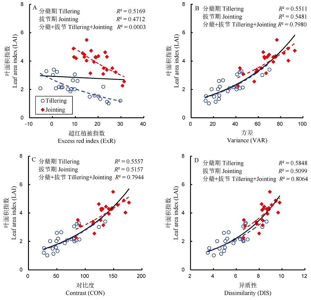
Fig. 2. Monitoring models of rice leaf area index (LAI) based on color indices and texture features.
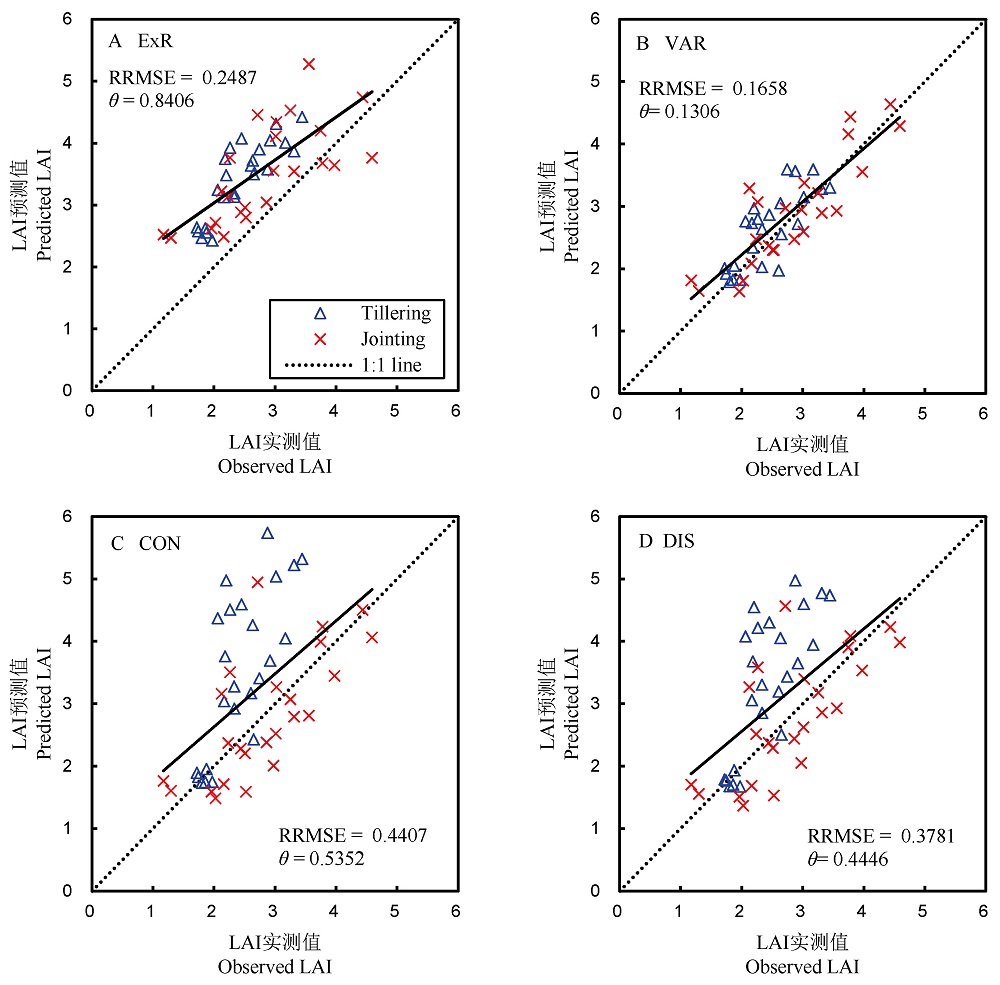
Fig. 3. Validation of rice leaf area index (LAI) monitoring models based on color indices and texture features.
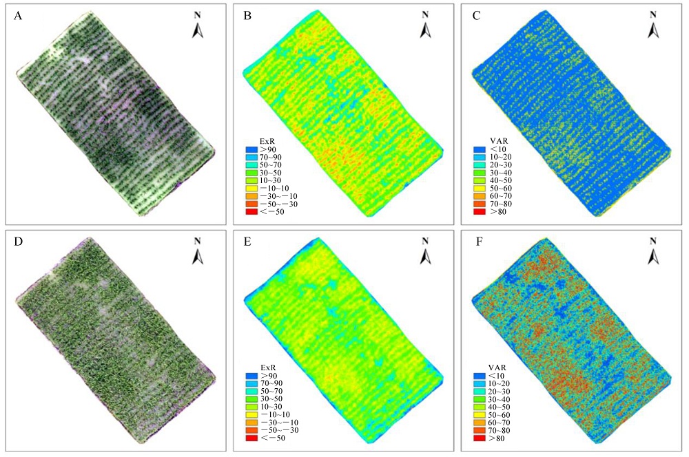
Fig. 4. Distribution of color index ExR and texture feature VAR in rice plot. A, Original image of tillering stage; B, Distribution of ExR at tillering stage; C, Distribution of VAR at tillering stage; D, Original image of jointing stage; E, Distribution of ExR at jointing stage; F, Distribution of VAR at jointing stage.
| [1] | 龚金龙, 邢志鹏, 胡雅杰, 张洪程, 戴其根, 霍中洋, 许轲, 魏海燕, 高辉. 籼、粳超级稻光合物质生产与转运特征的差异[J]. 作物学报, 2014, 40(3): 497-510. |
| Gong J L, Xing Z P, Hu Y J, Zhang H C, Dai Q G, Huo Z Y, Xu K, Wei H Y, Gao H. Difference of characteristics of photosynthesis, matter production and translocation between indica and japonica super rice[J]. Acta Agronomica Sinica, 2014, 40(3): 497-510. (in Chinese with English abstract) | |
| [2] | 姜元华, 许轲, 赵可, 孙建军, 韦还和, 许俊伟, 魏海燕, 郭保卫, 霍中洋, 戴其根, 张洪程. 甬优系列籼粳杂交稻的冠层结构与光合特性[J]. 作物学报, 2015, 41(2): 286-296. |
| Jiang Y H, Xu K, Zhao K, Sun J J, Wei H H, Xu J W, Wei H Y, Guo B W, Huo Z Y, Dai Q G, Zhang H C. Canopy structure and photosynthetic characteristics of Yongyou series of indica-japonica hybrid rice under high-yielding cultivation condition[J]. Acta Agronomica Sinica, 2015, 41(2): 286-296. (in Chinese with English abstract) | |
| [3] | 殷尧翥, 郭长春, 孙永健, 武云霞, 余华清, 孙知白, 张桥, 王海月, 杨志远, 马均. 稻油轮作下油菜秸秆还田与水氮管理对杂交稻群体质量和产量的影响[J]. 中国水稻科学, 2019, 33(3): 257-268. |
| Yin Y Z, Guo C C, Sun Y J, Wu Y X, Yu H Q, Sun Z B, Zhang Q, Wang H Y, Yang Z Y, Ma J. Effects of rape straw retention and water and nitrogen management on population quality and yield of hybrid rice under rice-rape rotation[J]. Chinese Journal of Rice Science, 2019, 33(3): 257-268. (in Chinese with English abstract) | |
| [4] | 侯佳敏, 罗宁, 王溯, 孟庆锋, 王璞. 增密对我国玉米产量-叶面积指数-光合速率的影响[J]. 中国农业科学, 2021, 54(12): 2538-2546. |
| Hou J M, Luo N, Wang S, Meng Q F, Wang P. Effects of increasing planting density on grain yield, leaf area index and photosynthetic rate of maize in China[J]. Scientia Agricultura Sinica, 2021, 54(12): 2538-2546. (in Chinese with English abstract) | |
| [5] | 李艳大, 孙滨峰, 曹中盛, 叶春, 舒时富, 黄俊宝, 何勇. 基于作物生长监测诊断仪的双季稻叶面积指数监测模型[J]. 农业工程学报, 2020, 36(10): 141-149. |
| Li Y D, Sun B F, Cao Z S, Ye C, Shu S F, Huang J B, He Y. Model for monitoring leaf area index of double cropping rice based on crop growth monitoring and diagnosis apparatus[J]. Transactions of the Chinese Society of Agricultural Engineering(Transactions of the CSAE) , 2020, 36(10): 141-149. (in Chinese with English abstract) | |
| [6] | Qiao K, Zhu W Q, Xie Z Y, Li, P X. Estimating the seasonal dynamics of the leaf area index using piecewise LAI-VI relationships based on phenophases[J]. Remote Sensing, 2019, 11(6): 689. |
| [7] | 李艳大, 舒时富, 陈立才, 叶春, 王康军, 黄俊宝. 基于归一化法的双季稻叶面积指数动态预测模型[J]. 中国农学通报, 2017, 33(29): 77-84. |
| Li Y D, Shu S F, Chen L C, Ye C, Wang K J, Huang J B. A predict model of dynamic leaf area index of double cropping rice based on normalized method[J]. Chinese Agricultural Science Bulletin, 2017, 33(29): 77-84. (in Chinese with English abstract) | |
| [8] | Campos-Taberner M, García-Haro F J, Camps-Valls G, Grau-Muedra G, Nutini F, Crema A, Boschetti M. Multitemporal and multiresolution leaf area index retrieval for operational local rice crop monitoring[J]. Remote Sensing of Environment, 2016, 187: 102-118. |
| [9] | 张漫, 苗艳龙, 仇瑞承, 季宇寒, 李寒, 李民赞. 基于车载三维激光雷达的玉米叶面积指数测量[J]. 农业机械学报, 2019, 50(6): 12-21. |
| Zhang M, Miao Y L, Qiu R C, Ji Y H, Li H, Li M Z. Maize leaf area index measurement based on vehicle 3D LiDAR[J]. Transactions of the Chinese Society for Agricultural Machinery, 2019, 50(6): 12-21. (in Chinese with English abstract) | |
| [10] | 牛小桃, 樊军, 王胜, 王秋铭. 利用鱼眼摄像机测量植被叶面积指数动态变化[J]. 应用生态学报, 2018, 29(10): 3183-3190. |
| Niu X T, Fan J, Wang S, Wang Q M. measuring the dynamic of leaf area index of vegetation using fisheye camera[J]. Chinese Journal of Applied Ecology, 2018, 29(10): 3183-3190. (in Chinese with English abstract) | |
| [11] | 刘杨, 冯海宽, 黄珏, 孙乾, 杨福芹, 杨贵军. 基于无人机高光谱影像的马铃薯株高和地上生物量估算[J]. 农业机械学报, 2021, 52(2): 188-198. |
| Liu Y, Feng H K, Huang J, Sun Q, Yang F Q, Yang G J. Estimation of potato plant height and above-ground biomass based on UAV hyperspectral images[J]. Transactions of the Chinese Society for Agricultural Machinery, 2021, 52(2): 188-198. (in Chinese with English abstract) | |
| [12] | 宋勇, 陈兵, 王琼, 苏维, 孙乐鑫, 赵静, 韩焕勇, 王方永. 无人机遥感监测作物病虫害研究进展[J]. 棉花学报, 2021, 33(3): 291-306. |
| Song Y, Chen B, Wang Q, Su W, Sun L X, Zhao J, Han H Y, Wang F Y. Research advances of crop diseases and insect pests monitoring by unmanned aerial vehicle remote sensing[J]. Cotton Science, 2021, 33(3): 291-306. (in Chinese with English abstract) | |
| [13] | Zhang L Y, Zhang H H, Niu Y X, Han W T. Mapping maize water stress based on UAV multispectral remote sensing[J]. Remote Sensing, 2019, 11(6): 605. |
| [14] | 江杰, 张泽宇, 曹强, 田永超, 朱艳, 曹卫星, 刘小军. 基于消费级无人机搭载数码相机监测小麦长势状况研究[J]. 南京农业大学学报, 2019, 42(4): 622-631. |
| Jiang J, Zhang Z Y, Cao Q, Tian Y C, Zhu Y, Cao W X, Liu X J. Use of a digital camera mounted on a consumer-grade unmanned aerial vehicle to monitor the growth status of wheat[J]. Journal of Nanjing Agricultural University, 2019, 42(4): 622-631. (in Chinese with English abstract) | |
| [15] | 高林, 杨贵军, 李红军, 李振海, 冯海宽, 王磊, 董锦绘, 贺鹏. 基于无人机数码影像的冬小麦叶面积指数探测研究[J]. 中国生态农业学报, 2016, 24(9): 1254-1264. |
| Gao L, Yang G J, Li H J, Li Z H, Feng H K, Wang L, Dong J H, He P. Winter wheat LAI estimation using unmanned aerial vehicle RGB-imaging[J]. Chinese Journal of Eco-Agriculture, 2016, 24(9): 1254-1264. (inChinese with English abstract) | |
| [16] | Hunt E R, Cavigelli M, Daughtry C, Mcmurtrey J E, Walthall C L. Evaluation of digital photography from model aircraft for remote sensing of crop biomass and nitrogen status[J]. Precision Agriculture, 2005, 6(4): 359-378. |
| [17] | 万亮, 岑海燕, 朱姜蓬, 张佳菲, 杜晓月, 何勇. 基于纹理特征与植被指数融合的水稻含水量无人机遥感监测[J]. 智慧农业(中英文), 2020, 2(1): 58-67. |
| Wan L, Cen H Y, Zhu J P, Zhang J F, Du X Y, He Y. Using fusion of texture features and vegetation indices from water concentration in rice crop to UAV remote sensing monitor[J]. Smart Agriculture, 2020, 2(1): 58-67. (in Chinese with English abstract) | |
| [18] | 陈鹏飞, 梁飞. 基于低空无人机影像光谱和纹理特征的棉花氮素营养诊断研究[J]. 中国农业科学, 2019, 52(13): 2220-2229. |
| Chen P F, Liang F. Cotton nitrogen nutrition diagnosis based on spectrum and texture feature of images from low altitude unmanned aerial vehicle[J]. Scientia Agricultura Sinica, 2019, 52(13): 2220-2229. (in Chinese with English abstract) | |
| [19] | Konôpka B, Pajtík J, Marušák R, Boše’a M, Lukac M. Specific leaf area and leaf area index in developing stands of Fagus sylvatica L. and Piceaabies karst[J]. Forest Ecology and Management, 2016, 364: 52-59. |
| [20] | Shibayama M C, Sakamoto T H, Takada E J, Inoue A H, Morita K H, Yamaguchi T K Y, Takahashi W T R, Kimura A H. Estimating rice leaf greenness (SPAD) using fixed-point continuous observations of visible red and near infrared narrow-band digital images[J]. Plant Production Science, 2012, 15(4): 293-309. |
| [21] | Meyer G E, Hindman T W, Laksmi K. Machine vision detection parameters for plant species identification[J]. Proceedings of SPIE: The International Society for Optical Engineering, 1999, 3543: 327-335. |
| [22] | Meyer G E, Neto J C. Verification of color vegetation indices for automated crop imaging applications[J]. Computers and Electronics in Agriculture, 2008, 63(2): 282-293. |
| [23] | Gitelson A A, Kaufman Y J, Stark R, Rundquist D. Novel algorithms for remote estimation of vegetation fraction[J]. Remote Sensing of Environment, 2002, 80(1): 76-87. |
| [24] | Louhaichi M, Borman M M, Johnson D E. Spatially located platform and aerial photography for documentation of grazing impacts on wheat[J]. Geocarto International, 2001, 16(1): 65-70. |
| [25] | Haralick R M, Shanmugam K, Dinstein I. Textural features for image classification[J]. Studies in Media and Communication, 1973, SMC-3(6): 610-621. |
| [26] | Cao Z S, Cheng T, Ma X, Tian Y C, Zhu Y, Yao X, Chen Q, Liu S Y, Guo Z Y, Zhen Q M, Li X. A new three-band spectral index for mitigating the saturation in the estimation of leaf area index in wheat[J]. International Journal of Remote Sensing, 2017, 38(13): 3865-3885. |
| [27] | Bendig J, Yu K, Aasen H, Bolten A, Bennertz S, Broscheit J, Gnyp M L, Bareth G. Combining UAV-based plant height from crop surface models, visible, and near infrared vegetation indices for biomass monitoring in barley[J]. International Journal of Applied Earth Observation and Geoinformation, 2015, 39: 79-87. |
| [28] | 郑恒彪. 水稻生育期及生长参数的近地面遥感监测研究[D]. 南京: 南京农业大学, 2018. |
| Zheng H B. Monitoring rice phenology and growth parameters using near-ground remote sensing platforms[D]. Nanjing: Nanjing agricultural university, 2018, Nanjing. (in Chinese with English abstract) | |
| [29] | Sun B, Wang C F, Yang C H, Xu B D, Zhou G S, Li X Y, Xie J, Xu S J, Liu B, Xie T J, Kuai J, Zhang J. Retrieval of rapeseed leaf area index using the PROSAIL model with canopy coverage derived from UAV images as a correction parameter[J]. International Journal of Applied Earth Observation and Geoinformation, 2021, 102: 102373. |
| [30] | Ciganda V S, Gitelson A A, Schepers J. How deep does a remote sensor sense? Expression of chlorophyll content in a maize canopy[J]. Remote Sensing of Environment, 2012, 126: 240-247. |
| [31] | Mishra P, Nordon A, Mohd A, Mohd S, Lian, G P, Redfern S. Fusing spectral and textural information in near-infrared hyperspectral imaging to improve green tea classification modelling[J]. Journal of Food Engineering, 2019, 249: 40-47. |
| [32] | Duan M Q, Zhang X G. Using remote sensing to identify soil types based on multiscale image texture features[J]. Computers and Electronics in Agriculture, 2021, 187: 106272. |
| [1] | GUO Zhan, ZHANG Yunbo. Research Progress in Physiological,Biochemical Responses of Rice to Drought Stress and Its Molecular Regulation [J]. Chinese Journal OF Rice Science, 2024, 38(4): 335-349. |
| [2] | WEI Huanhe, MA Weiyi, ZUO Boyuan, WANG Lulu, ZHU Wang, GENG Xiaoyu, ZHANG Xiang, MENG Tianyao, CHEN Yinglong, GAO Pinglei, XU Ke, HUO Zhongyang, DAI Qigen. Research Progress in the Effect of Salinity, Drought, and Their Combined Stresses on Rice Yield and Quality Formation [J]. Chinese Journal OF Rice Science, 2024, 38(4): 350-363. |
| [3] | XU Danjie, LIN Qiaoxia, LI Zhengkang, ZHUANG Xiaoqian, LING Yu, LAI Meiling, CHEN Xiaoting, LU Guodong. OsOPR10 Positively Regulates Rice Blast and Bacterial Blight Resistance [J]. Chinese Journal OF Rice Science, 2024, 38(4): 364-374. |
| [4] | CHEN Mingliang, ZENG Xihua, SHEN Yumin, LUO Shiyou, HU Lanxiang, XIONG Wentao, XIONG Huanjin, WU Xiaoyan, XIAO Yeqing. Typing of Inter-subspecific Fertility Loci and Fertility Locus Pattern of indica-japonica Hybrid Rice [J]. Chinese Journal OF Rice Science, 2024, 38(4): 386-396. |
| [5] | DING Zhengquan, PAN Yueyun, SHI Yang, HUANG Haixiang. Comprehensive Evaluation and Comparative Analysis of Jiahe Series Long-Grain japonica Rice with High Eating Quality Based on Gene Chip Technology [J]. Chinese Journal OF Rice Science, 2024, 38(4): 397-408. |
| [6] | HOU Xiaoqin, WANG Ying, YU Bei, FU Weimeng, FENG Baohua, SHEN Yichao, XIE Hangjun, WANG Huanran, XU Yongqiang, WU Zhihai, WANG Jianjun, TAO Longxing, FU Guanfu. Mechanisms Behind the Role of Potassium Fulvic Acid in Enhancing Salt Tolerance in Rice Seedlings [J]. Chinese Journal OF Rice Science, 2024, 38(4): 409-421. |
| [7] | LÜ Zhou, YI Binghuai, CHEN Pingping, ZHOU Wenxin, TANG Wenbang, YI Zhenxie. Effects of Nitrogen Application Rate and Transplanting Density on Yield Formation of Small Seed Hybrid Rice [J]. Chinese Journal OF Rice Science, 2024, 38(4): 422-436. |
| [8] | HU Jijie, HU Zhihua, ZHANG Junhua, CAO Xiaochuang, JIN Qianyu, ZHANG Zhiyuan, ZHU Lianfeng. Effects of Rhizosphere Saturated Dissolved Oxygen on Photosynthetic and Growth Characteristics of Rice at Tillering Stage [J]. Chinese Journal OF Rice Science, 2024, 38(4): 437-446. |
| [9] | WU Yue, LIANG Chengwei, ZHAO Chenfei, SUN Jian, MA Dianrong. Occurrence of Weedy Rice Disaster and Ecotype Evolution in Direct-Seeded Rice Fields [J]. Chinese Journal OF Rice Science, 2024, 38(4): 447-455. |
| [10] | LIU Fuxiang, ZHEN Haoyang, PENG Huan, ZHENG Liuchun, PENG Deliang, WEN Yanhua. Investigation and Species Identification of Cyst Nematode Disease on Rice in Guangdong Province [J]. Chinese Journal OF Rice Science, 2024, 38(4): 456-461. |
| [11] | CHEN Haotian, QIN Yuan, ZHONG Xiaohan, LIN Chenyu, QIN Jinghang, YANG Jianchang, ZHANG Weiyang. Research Progress on the Relationship Between Rice Root, Soil Properties and Methane Emissions in Paddy Fields [J]. Chinese Journal OF Rice Science, 2024, 38(3): 233-245. |
| [12] | MIAO Jun, RAN Jinhui, XU Mengbin, BO Liubing, WANG Ping, LIANG Guohua, ZHOU Yong. Overexpression of RGG2, a Heterotrimeric G Protein γ Subunit-Encoding Gene, Improves Drought Tolerance in Rice [J]. Chinese Journal OF Rice Science, 2024, 38(3): 246-255. |
| [13] | YIN Xiaoxiao, ZHANG Zhihan, YAN Xiulian, LIAO Rong, YANG Sijia, Beenish HASSAN, GUO Daiming, FAN Jing, ZHAO Zhixue, WANG Wenming. Signal Peptide Validation and Expression Analysis of Multiple Effectors from Ustilaginoidea virens [J]. Chinese Journal OF Rice Science, 2024, 38(3): 256-265. |
| [14] | ZHU Yujing, GUI Jinxin, GONG Chengyun, LUO Xinyang, SHI Jubin, ZHANG Haiqing, HE Jiwai. QTL Mapping for Tiller Angle in Rice by Genome-wide Association Analysis [J]. Chinese Journal OF Rice Science, 2024, 38(3): 266-276. |
| [15] | WEI Qianqian, WANG Yulei, KONG Haimin, XU Qingshan, YAN Yulian, PAN Lin, CHI Chunxin, KONG Yali, TIAN Wenhao, ZHU Lianfeng, CAO Xiaochuang, ZHANG Junhua, ZHU Chunqun. Mechanism of Hydrogen Sulfide, a Signaling Molecule Involved in Reducing the Inhibitory Effect of Aluminum Toxicity on Rice Growth Together with Sulfur Fertilizer [J]. Chinese Journal OF Rice Science, 2024, 38(3): 290-302. |
| Viewed | ||||||
|
Full text |
|
|||||
|
Abstract |
|
|||||